LIS WRF Hydro Update February 2020
For this release, LIS/WRF-Hydro configured using the Noah-MP v4.0.1 LSM to resolve vertical fluxes, has been benchmarked with an otherwise equivalent WRF-Hydro simulation. This is to ensure the robustness of the design and scheme used for coupling LIS and WRF-Hydro. LIS/WRF-Hydro uses Earth System Modeling Framework (ESMF) regridding functions combined with a National Unified Operational Prediction Capability (NUOPC) object oriented coding framework to enable the interaction of LSMs within NASA LIS and hydrologic routing through WRF-Hydro in a single model executable. This interoperable system also uses mediators between the two models to enable data-assimilation. This update includes the results of the benchmarking of this new system compared to standalone WRF-Hydro.
WRF-Hydro as a default uses Noah-MP v4.0.1, and these results are verified with respect to ET, soil moisture, and streamflow in the Tar River Basin in North Carolina. Results are also shown in the Tuolumne River basin in California; however, differences in the model albedo scheme for snowcover result in some differences in the hydrologic response of the basin here. The latest
LIS/WRF-Hydro release is available here: https://github.com/NESII/lishydro
Since the most recent release, LIS/WRF-Hydro has been updated to include Noah-MP v4.0.1. This was a milestone since the previous release because it permits LIS/WRF-Hydro to be executed using the same LSM as WRF-Hydro (previously the latest Noah-MP LSM version for LIS/WRF-Hydro was Noah-MP v3.6). This change to the LIS/WRF-Hydro structure ameliorates many of the model differences between LIS/WRF-Hydro and standalone WRF-Hydro from the last release.
Due to differences in the update cycle between LIS/WRF-Hydro and standalone WRF-Hydro, Noah-MP v4.0.1 in WRF-Hydro remains different from the LIS/WRF-Hydro release. These differences are unavoidable, as WRF-Hydro releases are often consistent with the NOAA National Water Model (NWM) update cycle, while LIS updates are limited by the difficulties of incorporating bug fixes to Noah-MP in the LIS structure, which must be compatible with other LSMs in addition to Noah-MP.
To address these issues, the latest release of LIS/WRF-Hydro includes a separate NESII/LISF GitHub branch (https://github.com/NESII/LISF/tree/wrf_hydro_valid_fix) that includes a code change to Noah-MP v4.0.1. In this branch, effective Leaf Area Index (LAI) is no longer normalized by vegetation fraction. In order for LIS/WRF-Hydro to stay consistent with official LIS code, this change remains in the GitHub branch for the near future. The changes to the LIS/WRF-Hydro code are as follows: https://github.com/NESII/LISF/commit/3e38667cf750c1288e49b9e5b0a0743b460f0292
WRF-Hydro Effective LAI Calculation (included in GitHub branch noted above): VAIE = MIN(6.,VAI ) LAISUNE = MIN(6.,LAISUN ) LAISHAE = MIN(6.,LAISHA )
LIS Noah-MP v4.0.1 Effective LAI Calculation: VAIE = MIN(6.,VAI / FVEG) LAISUNE = MIN(6.,LAISUN / FVEG) LAISHAE = MIN(6.,LAISHA / FVEG)
Note that to utilize this branch, the user must manually check out this branch of the NESII/LISF repository when compiling LIS/WRF-Hydro.
This update to LIS/WRF-Hydro also includes a capability to execute LIS/WRF-Hydro using multiple ensembles of WRF-Hydro, for one LIS simulation (i.e. one LIS simulation to many WRF-Hydro simulations). While this capability has few practical uses at this time (an ensemble of LIS simulations is required for some LIS data-assimilation schemes); this preliminary step is part of ongoing development to combine LIS data-assimilation capabilities with LIS/WRF-Hydro.
The latest release of LIS/WRF-Hydro is benchmarked in the Tar River basin, which is a 5866.52 km2 coastal watershed with headwaters in the mountains of North Carolina (Figure 1). This benchmarking exercise utilizes a cold-start initialized on 1 October 2015, and is executed for 6 months. Snowmelt has limited impacts in this region; however, the model domain did experience a few minor snow events during this analysis period.
We also demonstrate LIS/WRF-Hydro in the 4850.56 km2 Tuolumne River basin in Central California (Figure 1). Due to the high elevations in the headwaters of this basin, this basin is subject to substantial snowmelt, so our benchmarking considers WY2016 and the cold season of WY2017, wet and dry winters, respectively.
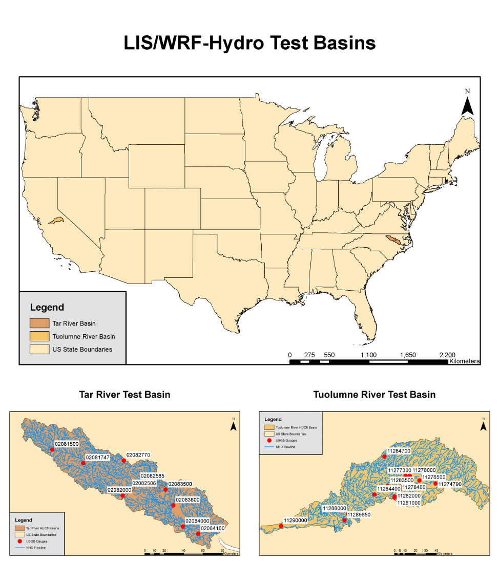 Figure 1: Tar and Tuolumne test basins (top) are shown relative to the Contiguous US (CONUS) (top). Each basin is plotted with USGS gauges and NHD flowlines in the bottom two panels.
After the LAI normalization fix, LIS/WRF-Hydro is able to produce nearly equivalent hydrographs to a control WRF-Hydro simulation (Figure 2) in the Tar River basin. This is true in both the upper basin (e.g. USGS 02081500 and USGS 02082770) as well as the lower basin (e.g. USGS 02083500 and USGS 02084000). These results demonstrate that the coupling of LIS and WRF-Hydro through the ESMF regridding scheme and the NUOPC caps is capable of producing an equivalent hydrograph to WRF-Hydro using the Noah-MP v.4.0.1 LSM without unexpected results or anomalies.
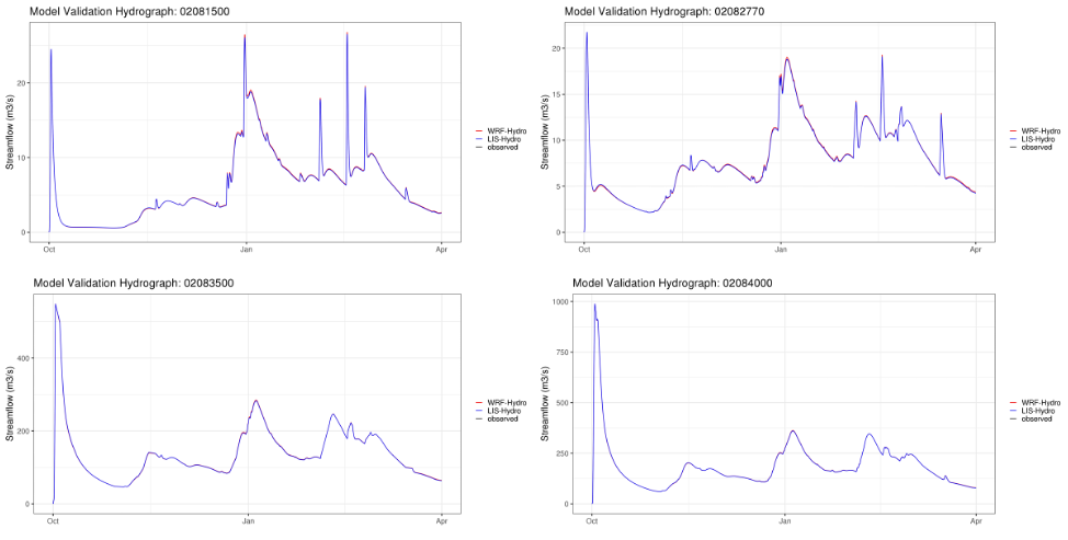 Figure 2: WRF-Hydro (red) and LIS/WRF-Hydro (blue) streamflow are shown at USGS Gauge 02081500 (Tar River headwaters; top left), USGS Gauge 02082770 (Swift Creek at Hilliardston, NC; top right), USGS Gauge 02083500 (Tar River at Tarboro, NC; bottom left), and USGS Gauge 02084000 (Tar River at Greenville, NC).
Other model variables from the full Tar River basin domain are shown in Figure 3. Note that this analysis includes areas covered by water, where LIS is inactive. Both models produce nearly equivalent snow water equivalent (SWE); however, canopy evaporation varies due to some differences in the Noah-MP (LIS/WRF-Hydro v. WRF-Hydro) calculation of the Monin-Obukov length and the leaf boundary layer resistance. These differences also effect transpiration and bare soil evaporation (Figure 3), but to a relatively lesser extent.
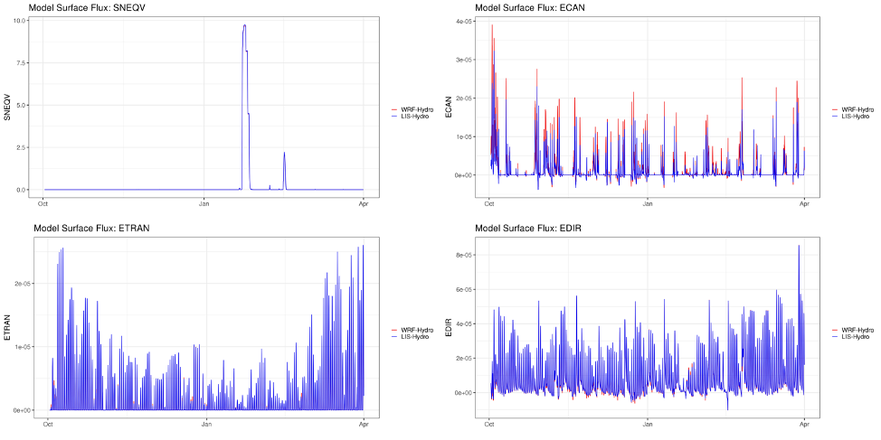 Figure 3: WRF-Hydro (red) and LIS/WRF-Hydro (blue) Tar River domain basin average (excluding water grid points) snow water equivalent (SNEQV; top left), canopy evaporation (ECAN; top right), transpiration (ETRAN; bottom left), and direct soil evaporation (EDIR; bottom right).
Streamflow is benchmarked in the Tuolumne basin for LIS/WRF-Hydro. WRF-Hydro and LIS/WRF-Hydro are both relatively close at USGS gauge 1129000, near the outlet of the basin; however, streamflow is impacted late in the season by differences in the snowmelt scheme. Early in the simulation, initial conditions appear to impact baseflow in the hydrograph; however, differences in snowmelt affect hydrologic response later in the 2016 water year. This is likely due to differences in the snow albedo scheme between Noah-MP in LIS/WRF-Hydro and WRF-Hydro. While there are some differences in this basin, these results still demonstrate that the hydrologic response between the two models is correct with respect to timing of major streamflow peaks.
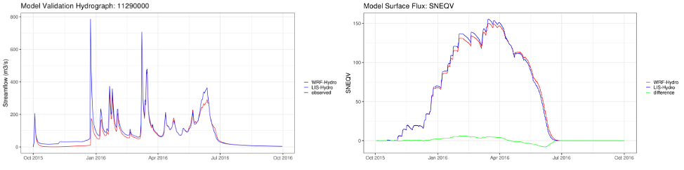 Figure 4: WRF-Hydro (red) and LIS/WRF-Hydro (blue) USGS Gauge 11290000 (Tuolumne River near Modesto, CA; left) streamflow and Tuolumne River domain basin average (excluding water grid points) snow water equivalent (SNEQV; right).