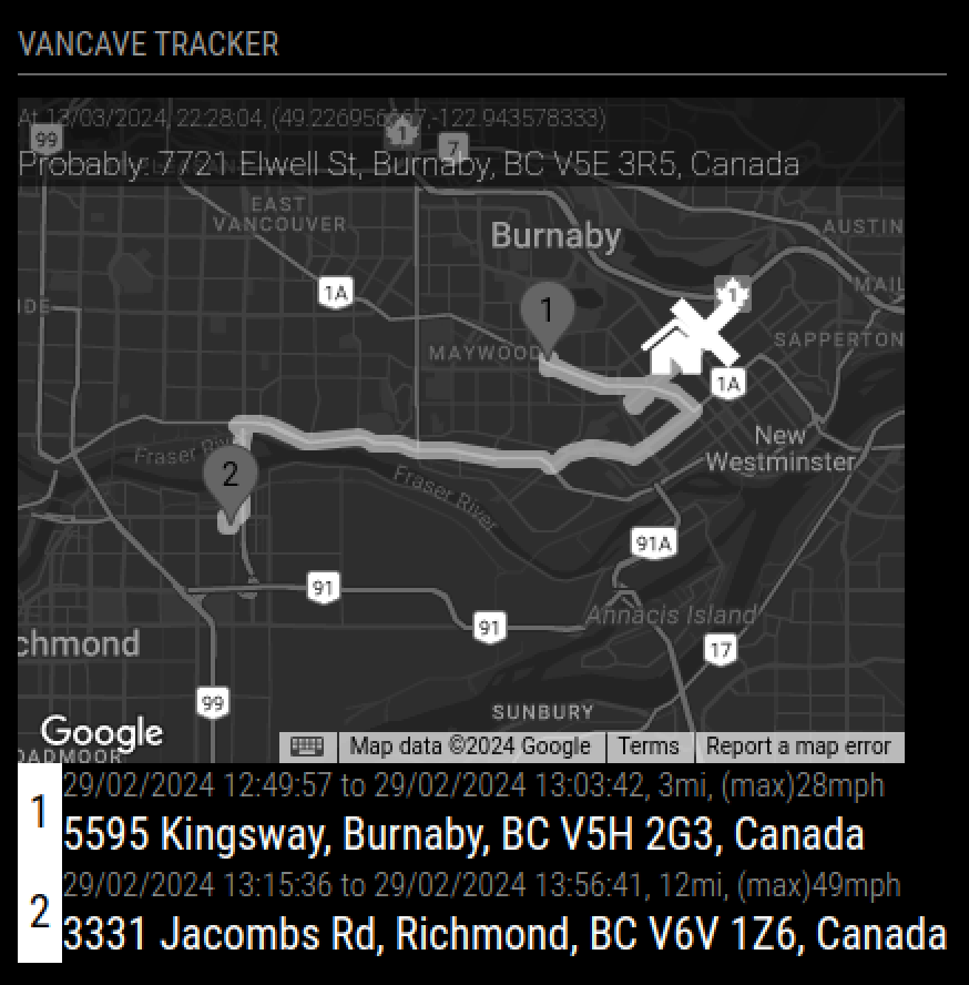
Displays GPS location from GPSD JSON, or GPX Path on Google Maps. Reverses Geocode to get closest address of GPS location, and will display closest address of anywhere it stopped in the path file. X is default marker for current GPS location, which is expected in the origin configuration. The pathurl configuration points to URL containing a list of GPS location reflecting a track of a GPS device, and is drawn as a bolded line on the map. Markers are placed where a stop occurred for more than 10min.
Your GPS location, and/or array of GPS coordinates, have to be supplied by yourself. This software does not interface with any GPS device.
The required data format is the typical JSON output produced by the Linux command:
gpspipe -wThe pathurl file has the above data, but separated by commas, and wrapped around in array brackets []. It only requires the records with TPV. It should ignore the others.
The origin file has the above data, but only 1 TPV record
The respective files above need to be stored in a file. And this file has to be either put in same directory as the .js files here (and the configuration changed to point to that file, instead of the sample files). Or it needs to be uploaded to a internet accessible URL, and the configuration for origin and pathurl changed to reflect the url where the JSON can be read. The gpspipe command is available on most Linux systems with a GPS device connected, and has GPSD installed. https://kickstartembedded.com/2022/07/23/a-beginners-guide-to-using-gpsd-in-linux/
I upload both a origin and path file to a URL, and update the config to reflect both, so the module will read the respective URL and display.
| Path |
|---|
 . . |
Note
Uses Google Maps Geocode API, to get addresses from coordinates. Google Maps Geocode API is described below, but you don't to understand it to get it to work: https://developers.google.com/maps/documentation/geocoding/requests-reverse-geocoding
Module to be installed in the MagicMirror application, described in below link.
https://github.com/MagicMirrorOrg/MagicMirror
The MagicMirror application is built on the node.js application platform, and node.js package dependencies can be managed by npm application.
Directions API
Geocoding API
Maps JavaScript API
Maps Static API
Warning
Needs Google API key to work. You can obtain one here: https://console.cloud.google.com/apis/credentials. The key needs to have permissions to the API indicated above. Read my blog entry, if you want directions on how to get a Google API key, but you will need to supply a Credit Card info. https://www.tictawf.com/blog/using-google-cloud-apis/
These commands entered on linux command line, will retreive the code for the module, and then install the dependency software from npm
cd <MagicMirror root>/modules/
git clone https://github.com/studio-1b/MMM-GoogleBusSchedule.git
cd MMM-GoogleBusSchedule
npm installAdd this entry to /config/config.js, as entry in modules: [ array, somewhere at end.
    {
        module: "MMM-GoogleMapGpx",
        header: "VanCave Tracker",
        position: "top_left",
        config: {
            width: 400,
            height: 300,
            apikey: "<GOOGLE_API_KEY>",
            marker: "marker2", // usually http://location, but marker1-6 has built in images
            origin: { lat: 49.22652, lon: -122.94399 },
            pathurl: "modules/MMM-GoogleMapGpx/sample_path.json",
        }
    },
You can use the 2x sample path and GPS files in github, for gps location, as a sample of putting GPS location in URL. You can use any URL, but we (mis-)use github as example.
    {
        module: "MMM-GoogleMapGpx",
        header: "VanCave Tracker",
        position: "top_left",
        config: {
            width: 400,
            height: 300,
            apikey: "<GOOGLE_API_KEY>",
            marker: "marker2", // usually http://location, but marker1-6 has built in images
            origin: "https://raw.githubusercontent.com/studio-1b/MMM-GoogleMapGpx/main/sample_gpx.json",
            pathurl: "https://raw.githubusercontent.com/studio-1b/MMM-GoogleMapGpx/main/sample_path.json",
        }
},There are 3 configuration important configuration items: Google API key, origin, and pathurl pathurl:
| Key | Description |
|---|---|
width 350 |
Width of Map |
height 300 |
Height of Map |
| apikey (required) |
Google API key, as specified above (ie. ) |
origin (required)modules/MMM-GoogleMapGpx/sample_path.json |
Can be static coordiantes, in javascript object with Latitude,Longitude (ie. {lat: 0, lon: 0} ) or a URL pointing to a JSON file with lat and lon attributes, which is rechecked for changes every minute. |
pathurl (required)modules/MMM-GoogleMapGpx/sample_path.json |
Has to contain URL to JSON file with array of TPV objects (ie. output from gpspipe -w, separated by commas, wrapped in array brackets[]) |
marker marker2 |
Can be marker1,marker2,marker3,marker4,marker5,marker6, or a URL to image |
pathCheckSchedule [500,700,900,1100,1200,1300,1400,1500,1600,1700,1800,1900,2000,2100,2200,] |
Array of any time formatted hhmm, when the path is updated |
TPV json file, in the URL pointed to, in origin configuration can look below, but only the lat and lon are necessary
{
  "class": "TPV",
  "device": "/dev/ttyUSB",
  "mode": 3,
  "time": "2024-03-10T06:01:05.000Z",
  "ept": 0.005,
  "lat": 45.226946667,
  "lon": -120.943606667,
  "alt": 118.8,
  "epx": 7.939,
  "epy": 11.676,
  "epv": 32.2,
  "track": 205.06,
  "speed": 0.036,
  "climb": -0.4,
  "eps": 23.35,
  "epc": 64.4
}
You will notice the above record for current location, is a very similar to the records below for a path. The easiest way to get the above, is simply to extract the latest record below.
The path json file, in the URL pointed to, in path configuration can look below, but only the lat,lon,time,speed are necessary.
[
{"class":"TPV","device":"/dev/ttyUSB0","mode":3,"time":"2024-02-29T21:56:38.000Z","ept":0.005,"lat":49.19041,"lon":-123.081038333,"alt":-0.1,"epx":7.546,"epy":11.611,"epv":34.5,"track":158.12,"speed":2.361,"climb":-0.1,"eps":23.22,"epc":69},
{"class":"TPV","device":"/dev/ttyUSB0","mode":3,"time":"2024-02-29T21:56:39.000Z","ept":0.005,"lat":49.190393333,"lon":-123.081023333,"alt":-0.1,"epx":7.546,"epy":11.611,"epv":34.5,"track":137.56,"speed":2.027,"climb":0,"eps":23.22,"epc":69},
{"class":"TPV","device":"/dev/ttyUSB0","mode":3,"time":"2024-02-29T21:56:40.000Z","ept":0.005,"lat":49.190383333,"lon":-123.081001667,"alt":-0.1,"epx":7.546,"epy":11.611,"epv":34.5,"track":114.46,"speed":1.945,"climb":0,"eps":23.22,"epc":69},
{"class":"TPV","device":"/dev/ttyUSB0","mode":3,"time":"2024-02-29T21:56:41.000Z","ept":0.005,"lat":49.19038,"lon":-123.080978333,"alt":-0.1,"epx":7.546,"epy":11.611,"epv":34.5,"track":97.01,"speed":1.667,"climb":0,"eps":23.22,"epc":69}
]
The data was generated above
gpspipe -wwhich creates data that looks like above, but without commas between records or the array brackets surrounding the entire file. Like below
{"class":"TPV","device":"/dev/ttyUSB0","mode":3,"time":"2024-02-29T21:56:38.000Z","ept":0.005,"lat":49.19041,"lon":-123.081038333,"alt":-0.1,"epx":7.546,"epy":11.611,"epv":34.5,"track":158.12,"speed":2.361,"climb":-0.1,"eps":23.22,"epc":69}
{"class":"TPV","device":"/dev/ttyUSB0","mode":3,"time":"2024-02-29T21:56:39.000Z","ept":0.005,"lat":49.190393333,"lon":-123.081023333,"alt":-0.1,"epx":7.546,"epy":11.611,"epv":34.5,"track":137.56,"speed":2.027,"climb":0,"eps":23.22,"epc":69}
{"class":"TPV","device":"/dev/ttyUSB0","mode":3,"time":"2024-02-29T21:56:40.000Z","ept":0.005,"lat":49.190383333,"lon":-123.081001667,"alt":-0.1,"epx":7.546,"epy":11.611,"epv":34.5,"track":114.46,"speed":1.945,"climb":0,"eps":23.22,"epc":69}
... other record types too
{"class":"TPV","device":"/dev/ttyUSB0","mode":3,"time":"2024-02-29T21:56:41.000Z","ept":0.005,"lat":49.19038,"lon":-123.080978333,"alt":-0.1,"epx":7.546,"epy":11.611,"epv":34.5,"track":97.01,"speed":1.667,"climb":0,"eps":23.22,"epc":69}
to create the data as the path file requires, grep can filter only for TPV records, and the jq command can wrap the output in brackets and places commas between the records
gpspipe -w | grep TPV | jq -s '.'